If you have preteens, you have probably wondered when to talk to them about certain delicate topics. In every home those topics may be different: the Three Wise Men, Santa Claus, the Tooth Fairy, where babies come from...
When is the right time to talk about these things? How long does it make sense to keep a little white lie alive to preserve the magic? And how much detail should we share?
The answer is not simple. In fact, even at home my wife and I often find it hard to agree 😅.
So I wanted to write this article, not to give anyone advice, but to share our experience and a reflection: not talking about certain things at the right time could also carry a risk, don't you think?
Note: Of course, the article has also been reviewed by my favorite editor, my wife 😜.
I think we often find it hard to talk about certain topics because, in a way, it means acknowledging that our children are growing up... and wow, they grow up so fast! 😭
But one thing is what we would like, and another is reality.
As much as we might want it, our children don't live in a bubble. In the end:
they spend a lot of time with their friends
with older children at school, after-school activities, siblings, cousins, etc.
they find things on the Internet, or another child does
and so on
That is why it is inevitable that, sooner or later, they will hear or see things. Sometimes those things reach them without them looking for them. Other times, they ask others or look for answers by themselves.
On the other hand, it is also normal for them to end up repeating things, often by imitation, and sometimes without really understanding what they mean.
In short, we often don't know exactly what they know or what they have understood, and that can lead us to misinterpret things 😕.
In any case, there is an undeniable truth that my son's tutor once told me:
Regardless of what we parents do or say,when one child "knows something", it is only a matter of time before the rest also "know it".
Because as soon as that topic comes up again, and one child sees that another child knows less, they may feel tempted to show off and "teach them a lesson", not only to prove that they know more, but also that they are "more grown up".
And whether we like it or not, let's accept it... it is inevitable. Hasn't it happened to us too? 😅
Our concern, as I imagine happens to many parents, is that postponing these conversations, telling "half-truths", or giving incomplete answers because we think they are still too young also has risks.
For example:
they may feel that they cannot talk to us about certain topics, and gradually lose trust and end up looking for answers elsewhere
they may receive or interpret information incorrectly and form mistaken ideas
But there is something I think is even harder: talking about these topics with other parents, because sometimes they feel like "taboo" subjects.
I don't know if this happens to you too, but we find it difficult to bring up these topics with other families. Sometimes because of:
fear of making someone uncomfortable
fear of creating conflict
fear that, simply by mentioning it, someone might think something has happened
And this is not about all families having to think alike or explain things in the same way. Every home has its own timing, values, and way of explaining things.
But we do believe it helps to be able to talk about these topics more naturally with other parents, sharing what conversations are appearing in our homes and how we are approaching them.
Not so that we all agree on everything or impose one criterion, but so we have a bit more context.
If our children hear something from other children, we can explain why in our family we have approached the topic differently, without them feeling that we have hidden the truth from them or that we are treating them as if they were younger than their friends.
And if we are the ones who talk about something at home, it may also help other families to know that this conversation might come up.
It is better that they hear it from us, calmly and with context, than through an incomplete version told by children. Because that is where the telephone game effect can easily appear: one child tells something halfway, another interprets it as best they can, a confusing version reaches home, and we parents end up worrying or misinterpreting what happened.
Talking about it among adults should be about paving the way and being a little more prepared if the conversation comes up.
And we often wonder: are there more parents in this same situation, wanting to talk about it but not daring to take the first step?
Since they were little, we have repeated to them that:
adults are not taught how to be parents, and that, although we do the best we know and can, we also make mistakes
they are the most important thing in our lives, and almost everything we do is done thinking about helping them grow into good people and be happier
One example is the books we read with them, with the goal of giving them tools to understand themselves better and better understand the world. Some are more emotional books, such as 'De mayor quiero ser feliz' or 'El emocionario'; other times, they are books about the body, such as "Tu cuerpo es tuyo", financial education, or other topics. We also try to help them understand that behind those books there are important "life lessons".
In the same way, when we read parenting books such as 'The Whole-Brain Child' or 'No-Drama Discipline', we also tell them about it. We want them to see that we are still learning how to be parents and that, if they ever think we are wrong, they should tell us, because they may very well be right.
For example, I have had to explain to my eldest son once or twice that, although perhaps I would have told him some things earlier, it is not always that simple.
I want him to understand that I also need to agree with his mother and that, even then, there may be other people in the family, such as grandparents, who don't share our opinion, and we try to find a balance.
At home, since they were little, we have explained the concept of a 'white lie': those harmless or well-intentioned lies that are sometimes told with the other person's wellbeing in mind, for example, to make them feel good, to "protect" them, or to avoid hurting their feelings.
And we have already explained one of them to our eldest.
For more complicated topics, which need to be introduced little by little, such as "where babies come from", we do two things.
1) Try to help him become aware of how his tastes change
For example, we sometimes use comments he makes to his younger brother, such as when he says that a game his brother suggests is "for little kids", to remind him that, although he now likes other games, not so long ago he also liked that kind of game.
Similarly, there was a time when he felt uncomfortable seeing two adults kissing on TV. We used that moment to explain to him that it was normal, that sometimes there are things that make us uncomfortable at certain ages and that this can change later on.
2) Try to help him become aware of how his maturity level changes
We help him see that there are things you only understand when you are older, and to do that we try to find examples from situations he has already experienced.
For example, we helped him see the impact it could have on his younger brother's behavior, vocabulary, etc., if he watched content or played games that our eldest liked, but that were not appropriate for his brother's age.
And we also helped him see that, even if we try to explain to his younger brother why he should not watch or play that, he is still not able to understand why it is not good for him.
And the same rule applies to both of them when it comes to content, games, etc. that we do not consider appropriate for certain ages at home: not because they are bad in themselves, but because they have not yet reached the maturity level needed to understand them properly.
Above all, what we always try to convey to them is that they can trust that we are doing what we believe is best for them, and that we want them to feel confident talking to us about any topic. Even if they notice that we are avoiding something, we would rather they insist and ask us why.
We try to make them feel that home is a safe space to talk, open up, and ask questions, and that when they do, we acknowledge and value it.
Although we hope all of this helps us maintain trust with our children, we still feel that an important piece of the puzzle is missing: being able to talk about these things with other parents.
In this article, I use “parents” to refer to both mothers and fathers, and “kids” to include both boys and girls. While I value inclusive language, I’m sharing our personal experience—my wife María and I are raising two sons—and we're comfortable with these terms to describe our family.
That said, everything I share here is intended for anyone raising, teaching, or caring for children, regardless of role, identity, or family structure.
I hope the language used doesn’t create a barrier for anyone.
⚠️ Content warning: this article contains a disturbing video and a minor spoiler from the miniseries Adolescence.
Fair warning: this is a long read—but parenting is a deep topic, and I wanted to explore it properly 😅.
Today I’ll explain how I use ChatGPT as support in trying to be a better dad.
And I say “as support,” not “as the main tool,” because I also lean on books, my wife, our families, people in our close circle, teachers, etc.
Example: You can see an example of this in the article Learn to Teach (at Home), which I wrote last year.
I’m sharing this after doing a bit of retrospection and reviewing all my ChatGPT conversations on this topic, hoping that my experience might be useful to you.
Just for context: I created my ChatGPT account in February 2023, and from that very first month, I’ve had questions about parenting.
I think most people would agree that when you have kids, your priorities shift—they become the most important thing in your life (spoiler... I’ll come back to this at the end).
I take it for granted that we all want to be good parents and do our best with what we know. But we also need to acknowledge that we make mistakes, like everyone. That said, there’s no need for self-flagellation—we also get a lot of things right, like reading articles like this to learn more 😜.
I really like something the author of the book "Guide for Imperfect Parents Who Understand Their Kids Are Imperfect Too" says (a gift from our sister-in-law a few Christmases ago): "Parenting is a beautiful opportunity to grow as a person, always remembering that we are NOT perfect, and our children don’t need to be either."
As if that weren’t enough, last week I finished watching the miniseries Adolescence, based on real events. It’s about a child who commits a crime and the guilt his parents feel, highlighting some of the modern-day challenges of parenting, especially those linked to technology.
Note: It dives into modern bullying, where social media plays a huge role. I’d argue most of today’s parents aren’t ready for this, because this wasn’t part of our own childhood. That’s why last year, Gabriel Zabal and I decided to organize a community talk for families on this topic. And we’re planning to do it again, because it’s essential to stay up to date.
Eddie Miller, played by Stephen Graham (the father in the show), breaking down in tears.
I admit I couldn’t hold back tears when the father says, "Forgive me, son. I should have done better." It’s impossible not to empathize with a devastated parent in that situation.
As I often tell my kids, we parents make mistakes too, but I also remind them that everyone has to take ownership of their part.
Because parenting is hard, right?
Just a few weeks ago, I told my eldest that there’s no school for parenting, that there’s no license you have to pass to become a parent.
Although, come to think of it... if you need a license to drive a car, maybe we should consider requiring something similar to raise a child—since, let’s face it, the responsibility is even greater 😅.
If you haven’t seen it and want a laugh, here’s the trailer for Idiocracy, a satire that takes things to the extreme (or maybe not so much?)—a future where intelligence has been replaced by collective stupidity 😂😂😂.
As parents, we constantly face doubts. Some are about our actions, others about what our children experience. Here are just a few of the questions that run through my head now and then. You might find them familiar:
About our actions:
Am I doing this right? Could I do it better?
Am I setting a good example?
Do I work too much? Do I spend enough time with them?
Did I overreact? How should I have responded?
Am I too impatient?
Am I too permissive? Or too strict?
Should I step in more? Or less?
Should I influence this? Or let them decide?
Am I being overprotective?
What am I doing wrong? Is this my fault?
How can I prevent them from going through what I did? Should I let them make their own mistakes?
About boundaries and autonomy:
Should I let them do this?
Should I give more freedom? Or less?
Do I let them do/watch this or not?
To what extent should I supervise? And how much trust should I place?
About what they go through:
Why are they doing this? Or why is this happening to them?
Are they doing it on purpose? Or unknowingly?
Why do they behave differently at home and at school?
How can I help them understand what happened?
About communication and values:
How do I talk about this without making things worse?
How do I explain it in a way they understand?
How do I instill certain values?
How do I achieve this without forcing, threatening, pressuring, or guilt-tripping them?
About development:
Is it too early to explain this?
How do I help them when they’re stuck? Do I let them try on their own?
How do I introduce this new routine or habit?
How do I handle their frustrations?
About motivation:
Should I encourage them to explore this? Or am I projecting my own interests?
Is it better to observe and support only if they show interest?
etc.
Sometimes we follow advice (whether we asked for it or not). Other times, we default to how we were raised, or we consciously choose a different path because times have changed or because we believe it's for the best.
But no matter what we do, it’s hard to shake the guilt when we feel we’ve done something wrong.
And that’s exactly why I’ll explain next how I’ve used ChatGPT to help navigate these parenting challenges.
But before that, let’s talk about something I think we shouldn’t overlook when using tools like ChatGPT in parenting: our children’s privacy.
Even if we use tools like ChatGPT in private and personal ways, that doesn’t eliminate the risks. In fact, by discussing our kids there, we could be engaging in a form of private digital sharenting—with consequences we don’t always consider.
Consider this:
Everything we share with ChatGPT is stored on their servers (in the U.S., under U.S. law).
Accounts can be hacked, or the servers themselves could suffer a data breach.
And I doubt you’d want that kind of sensitive information falling into the wrong hands—or ending up exposed online.
So my recommendation is to avoid sharing anything sensitive or easily traceable back to your child.
That said, I’ve spoken to both my wife and my eldest son about this. I not only asked for their consent to publish this article, but I also plan to continue doing so whenever I want to discuss personal topics using ChatGPT (or any other tool), as long as I believe the benefit outweighs the risk.
If this topic interests you, I’ve added more details in the Privacy Annex.
First, I used the free version for the first year, and since May 2024 I’ve subscribed to ChatGPT Plus (€23/month), which among other features, allows you to create Custom GPTs.
Types of attachment (secure, anxious, avoidant...)
Skills to reinforce at home based on developmental stage (household skills, time management, financial education, critical thinking, problem-solving, open culture...)
How to talk about the body, emotions, and relationships (what to say and how, depending on age)
To reflect on my parenting style:
Am I being too strict in some areas?
Are my reactions over the top?
To better understand certain behaviors or situations:
Why is it so hard for them to get up in the morning?
Why don’t they listen when I talk (e.g., if they’re watching TV)?
Why do they ignore me sometimes?
Why do they tell obvious little lies from such a young age?
Why do some fears appear (e.g., fear of someone breaking in, seeing themselves in a mirror at night...)?
Where does shyness come from, and how to work on it?
To adapt content to their age:
Rephrasing complex questions I don’t know how to explain well (e.g., the value of money: comparing $ vs € vs £)
Helping explain abstract concepts: terms (e.g., metaphor), differences (e.g., selfish vs greedy), medical conditions (e.g., epilepsy)
Explaining totally new topics (electricity, electronics, finance...)
Finding or creating stories/fables with a specific moral
Explaining Spanish sayings in kid-friendly ways
To find ideas, strategies, and tools:
Resolving conflicts (e.g., anger, jealousy, frustration from losing, from the younger sibling always being attended to first, etc.)
Finding new ways to introduce routines when the current one doesn’t work
Introducing or maintaining good habits (e.g., meditation)
Explaining how to do certain tasks well (e.g., highlighting or summarizing)
Coming up with ideas to make a school subject more appealing
Offering different ways to explain difficult concepts (e.g., reading analog clocks)
Tackling co-living challenges like when one child wants something just because the other one has it
Studying a subject (e.g., creating practice exercises—supervised)
Improving fine motor skills (e.g., creating dot-to-dot drawings)
To foster attitudes and skills:
Encouraging critical thinking from a young age
Sparking curiosity
Helping them become more assertive
Boosting self-confidence, autonomy, and love of self-learning
To explore science as a family in a fun and accessible way:
Ideas for robotics, 3D printing, and electronics projects
DIY experiments (like homemade bubble soap, etc.)
And yes, I know I could search for many of these things on Google too 😜—and I do.
That said, I’ve also occasionally used Perplexity, a handy tool for quickly getting up to speed on unfamiliar topics (e.g., I once used it to gather info about the game Fortnite before making a decision).
The benefits I get from it can mostly be summed up as:
It helps me answer my kids’ questions in ways I might not come up with on the spot1.
It makes me reflect, like I’m chatting (confidentially) with a stranger about the topic.
It gives me information I can cross-check with a professional (teacher, psychologist, etc.).
It helps me brainstorm.
It gives me new vocabulary to explore on my own.
It provides context on different topics.
(1) I always tell my kids: (1) you shouldn’t blindly trust ChatGPT, (2) you should only ask about topics you understand at least a little, and (3) it’s not a tool for them to use on their own just yet. But I do use it in front of them, read the answers out loud, and clarify when needed, so they can begin to grasp its biases and current limitations.
At home, ChatGPT doesn’t make the parenting decisions—we do, as a family.
Lastly, before wrapping up, I wanted to share a custom GPT I created in February this year, called Parenting Mentor, AI Expert. It’s designed to offer families a tool to help deal with some of the parenting challenges I’ve mentioned.
More specifically, it’s meant to guide moms and dads in problem-solving by analyzing root causes and exploring possible solutions.
💬 Note: it’s not intended for assigning it a task, but rather for having a dialogue.
⚠️ Reminder: for serious issues, always consult professionals.
As adults, it’s our responsibility to protect and weigh the risks vs benefits, especially when it comes to children under 14 (though my wife believes teens may need even more supervision and guidance).
Kids are more vulnerable in the digital world. We must act with extra caution, especially when using technologies like AI.
With tools like ChatGPT, it’s easy to share personal, emotional, or sensitive details without considering future consequences.
Even when using private accounts, the risk is never zero. Digital traces last, and what seems harmless today could be problematic tomorrow.
Even if a platform seems secure, no system is foolproof. Our accounts could be hacked—and we ourselves are often the weakest link.
We should avoid exposing our kids to real (or potential) harm:
Don’t share their full name, photos, voice, or any other identifiable data.
Avoid describing scenes that might be embarrassing, intimate, or sensitive.
We have to think long-term: What if this comes out when they’re older?
We must teach our kids the value of privacy and how to handle their own data. Involve them once they’re old enough.
If they’re mature enough, we should ask their opinion: check if they’re okay with us sharing certain info about them—even if it’s just to ask an AI for advice.
We should only share when the goal is to protect, educate, or address a real need.
And throughout all of this, we must remember: the best interest of the child always comes first.
So if you’re thinking of using any tool for parenting, my advice is: do it cautiously.
Despite everything, I believe that today, as parents, we have more resources and information than ever before to raise our kids well—books, videos, games, studies, AI tools like ChatGPT, and many others.
At the same time, we live in an era where things change at lightning speed, and while that brings opportunities, it also brings risks.
Let’s use what we have to stay informed, improve as parents, and reduce those risks.
Times have changed. It’s easy to fall behind and miss what might be affecting our kids.
As I said earlier, it’s true that from the moment they’re born, our children become the most important thing in our lives.
But remember: just like they tell you on a plane to put on your oxygen mask first before helping others, in life, we also need to take care of ourselves in order to care for them.
We need to be well—physically and mentally—because if we’re not, we can’t be good parents.
That means:
Don’t confuse "they’re the most important" with "they must be the top priority at all times."
If you mess up, if you stumble, get back up and keep going. Don’t beat yourself up with guilt: we all make mistakes.
They also need to understand that just like them, we need self-love and self-care to be present for others.
And even so, we’ll keep making mistakes. As someone close told me not long ago: “Raúl, no matter what you do, when they grow up, they’ll always have something to blame you for.”
And honestly? I believe it. I did the same with my own parents 😓.
That said, I won’t worry too much about the future. I’ll focus on enjoying the present—because that’s all we really have, and doing my best (with all my flaws and limitations). I’ll try, as much as I can, to keep learning and improving.
For now, I’ll continue exploring how AI can help my kids (and others) grow and thrive. I’ll keep sharing updates with other families through the AI and Education Podcast and in events at my kids’ school.
And I also want to:
Publish an article I’ve been working on—co-created with my son’s teacher and ChatGPT—on dealing with “little white lies” in early childhood.
Finish a "plan" I’m creating with the help of AI to use at home:
To understand and remind ourselves what skills and knowledge to focus on at each stage of parenting, based on our kids’ maturity level.
To know what we can do to put those ideas into practice.
To reflect on how to instill values and attitudes throughout the process.
If anything I’ve shared here resonated with you, I’d love to hear from you. Have you considered using AI in parenting? What questions or insights have come up for you? Feel free to reach out or share in the comments.
Let’s start with sharenting—something increasingly common in today’s society. Even if done with the best intentions, many parents don’t realize what it really means (and it’s not our fault if no one taught us about it).
A picture is worth a thousand words, so I’ll share a video on this topic—a tough watch, but important:
It’s a powerful reminder that we parents have a duty to protect our children’s image and privacy—especially when they don’t yet have the cognitive tools to understand the consequences of data sharing or how to defend themselves against more complex threats.
María and I have always tried to be very cautious about what personal info is shared about our kids online (on social media, etc.), and we’ve decided to deny consent by default for third parties to share their image.
It’s our responsibility to protect children’s right to privacy and image.
Depending on their age:
For children under 14:
We must protect their personal data, prevent its use without permission, and be cautious when sharing.
Give or deny consent on their behalf (though I think it’s best to talk it through with them and get their opinion).
Ensure we share only on platforms where we can request deletion of their data.
Avoid any form of profiling or influence.
For children 14 and older:
Help them understand the consequences of what they share and with whom.
Remind them they can delete their data or ask not to be tracked.
Teach them to recognize when their attention or data is being exploited.
Respect their space and privacy.
In any case, it is forbidden to share content that exposes, ridicules, embarrasses, or puts a child at risk—because that could lead to bullying, anxiety, or other negative effects down the line.
We named our talk after the Netflix miniseries (which we also used as a storytelling thread). Although my talk titles are usually more descriptive, this one had the intended effect — we exceeded my expectations for attendance, and apparently those of the organizers too, because the room was packed.
As stated in the abstract, this talk focused on the technical challenges and complexities of implementing map services at a global scale.
Our goals were:
Spark interest in the topic: Show some lesser-known but fascinating aspects of these services.
Highlight technical complexity: Reveal just how intricate these technologies are, and the level of software and data engineering required.
Value continuous effort: Emphasize the ongoing work involved in maintaining, improving, and innovating within map APIs, and hint at what’s coming next.
Help people make better tech decisions: Raise awareness of the variety of providers out there and improve the ability to choose the right mapping tech for future projects.
I usually don’t co-present, but after this experience, I think I should do it more often.
This time I really wanted it to be Juanma and me. Not just because we’ve had a great relationship for years, but also because we work at two of the most established companies in the industry (with over 100 years of combined experience). Plus, we complement each other really well — we cover the challenges from both a software and data perspective, not just for creating, but especially for keeping these services up to date.
The feedback we received both via the platform and in the hallways was excellent. In short:
What worked well:
People loved the content and many said it surprised them.
Several folks mentioned they had never stopped to consider the technical complexity behind these services.
Visual examples were especially appreciated — they helped people understand the concepts and challenges better.
Areas for improvement:
Consider the timing (it was the last talk of the day) and adjust pacing and depth accordingly.
Break the session into multiple parts next time to go into more detail.
Quite a few people told us they were feeling tired as it was the final talk of the day. Even so, the response was very positive (we scored 4.5 out of 5), despite the very fast pace (around 33 seconds per slide on average 😅).
Another reason I love Commit is that it brings together a lot of us who organize and run tech communities.
For the third year in a row, the organizers accepted our Open Spaces proposal, which is always a great opportunity to meet new people and learn from their experiences.
Note: In case you didn’t know, the “meta-community” we launched last year — Community Builders — was born from the idea of keeping these kinds of conversations going after events like this. 😍
At the closing session, I was invited onstage with the other communities to introduce each one. I took the chance to briefly explain what Community Builders is.
To wrap up, we had a post-conference dinner at Casa Mingo, where Álvaro and I brought together around 20 people who help run communities (including some who couldn’t attend the conference). A perfect way to end the event.
No doubt about it — these activities help us connect on a human level, something much harder to achieve remotely. Bonds are formed, relationships are strengthened, and there's a real sense of closeness that just doesn’t translate through video calls.
No offense to the other topics (there were some excellent talks, many of which are now on YouTube), but this year’s big star was AI. Of the 70 sessions, 17 focused on it — so pretty much at any given time, you could find a talk on Machine Learning or LLMs.
Here’s a quick rundown of themes and the interest I observed:
Practical AI integration in real-world apps
People are eager to understand how to embed AI into existing apps using commercial or open-source models without switching tech stacks.
Autonomous AI agent development
High curiosity around building agents that can learn and act on their own.
Security and auditing in generative models (LLMs)
Rising concern over the risks of generative AI — from running unknown code to accidentally introducing vulnerabilities. There's growing demand for tools that provide auditing and control.
Observability and performance (in production)
More and more interest in understanding LLM behavior in real time, with tools that offer metrics, logs, and traces to improve stability and performance.
Advancements in RAG architectures (RAG 2.0)
Curiosity around new variants that improve contextual retrieval.
AI on mobile devices
Moderate interest in running AI directly on phones without relying on the cloud.
AI applications in real-world scenarios
Less buzz overall, but still some interest in learning about how AI is being used in everyday situations.
I also had a bunch of hallway conversations worth sharing:
AI is replacing traditional platforms like Stack Overflow, Reddit, and Google Search for developers — tools like GitHub Copilot, Cursor.ai, and Windsurf are seen as faster, more tailored, and more efficient.
Vibe coding seems to be mostly well-received — as long as it's for small utilities, side projects, or low-risk tools (e.g., a command-line client for an API).
AI-assisted coding is becoming widespread (even among senior devs), often used for inspiration or to explore alternatives — though the code is always double-checked.
Some people pointed out how tempting it is to use AI with unfamiliar tech — the danger being that you may not catch mistakes or bad practices in the generated code.
Jon Vila shared a great insight: the risk of empowering less technical roles, like product managers, who start generating code with AI and then challenge development estimates.
AI is creeping into every phase of software development — from writing tests and documentation to generating test data and even creating pull requests.
As long as I can, I’ll keep going to Commit — because to me, it’s one of those rare events where you learn, connect, and leave with a full dose of community spirit. It’s intense, sure, but it’s an event where:
You learn a ton (in talks and in the hallways)
You meet new people
You reconnect with old friends
And it’s a meeting point for tons of tech communities
Thanks, thanks, and a thousand thanks to Laura, Abraham, Nacho, Kini, and all the volunteers and sponsors who made this event possible once again.
For much of my life, I’ve avoided sharing my opinions in public on controversial topics. Not because I don’t have any (I do, sometimes contradictory, politically incorrect, or evolving), but because I’ve been afraid of being misunderstood, judged, disliked, or disappointing people.
I’ve always felt uncomfortable with conflict. I’ve never liked picking sides or arguing about who’s right. I think I’ve tried to get along with everyone, often avoiding confrontation.
Maybe that’s why I’ve stayed quiet at times when sharing my thoughts could have brought value (even if it was uncomfortable).
While reflecting on this, I remembered something my dad used to tell me when I was a kid:
"Raúl, you should have friends even in hell." 👹🔥
It’s actually a pretty good piece of advice, though maybe I took it a bit too seriously. Or just misunderstood it 🤷.
Not long ago, I had a conversation with Francesc Puigvert that made me realize I’ve never really experienced the kind of “healthy rivalry” many people feel around football/soccer (since I’m not into it 😅). I’m not used to choosing sides. I shy away from confrontation.
Thinking it through, I came to a tough realization:
Silencing my opinions isn’t just a disservice to myself, it’s also, in part, cowardice. And more importantly, it’s not the example I want to set for my kids.
So this time, I’m going to be braver and share one of my “controversial” opinions (respectfully):
I believe in equality between men and women, and I believe feminism has been, and continues to be, necessary. But I also think that some aspects of modern feminism have strayed from the original goal of equality.
This is hard for me to say publicly, because I feel it’s one of those “politically incorrect” views that some might misinterpret as sexism.
Whenever I’ve shared this opinion with close friends, the response is almost always the same:
"Raúl, you’re not a beer 🍺. You can’t please everyone." 😂
I am who I am because of my experiences (just like everyone else). But I’ve learned that it’s important to express my ideas and opinions (with respect).
Fortunately, I don’t consider myself someone with fixed dogmas. What I believe today might shift tomorrow. I enjoy hearing solid arguments. I enjoy learning from people who see things differently. And when I share an opinion, it’s not because I think I hold the ultimate truth, but because I want others to understand me better, so we can understand each other better.
I’m also writing this because I want to lead by example. I want my kids to learn the same lessons I try to teach them with words:
They should be assertive, and not be afraid to express what they think, feel, or need, clearly and respectfully, without attacking others and without letting anyone disrespect them.
They should listen to, respect, and tolerate people who think differently, even if they disagree.
Changing your mind isn’t a weakness; it’s a sign of maturity and intelligence.
You can have a deep friendship with someone who sees the world completely differently.
And I say this because I live it (and I’m sure you do too 😉).
Many of the people I’m closest to hold opinions that are completely different from mine (on politics, religion, etc.), but that doesn’t stop us from loving each other.
Because a true friend is someone who really knows you, loves you for who you are (including your quirks), and even if they don’t always agree with you, they respect you, care about you, and are there when you need them.
That’s why I’ve decided to be more open, even in public. So people can get to know me better. And with a bit of luck, this will help me build more meaningful friendships.
Yes, some of my ideas might sound strange, naive, politically incorrect, or even uncomfortable. But all I want is to talk about them openly and respectfully, not to convince anyone, just so people can understand me a little better.
Mental note 🧠: If someone can’t appreciate me because we think differently... maybe it’s just not worth wasting time on, right? 🤷
If we want a better society, we need to show up as we are, listen more, judge less, and be more tolerant. If we only surround ourselves with people who think like us, we’re headed toward a more polarized and divided world. And that helps no one.
I’m still reflecting on my thoughts and ideas, and I hope to keep writing and sharing them here soon.
And if I ever say or do something you don’t agree with or don’t understand, I genuinely invite you to tell me (with kindness 😉). Really. Over a beer if needed... or a soft drink. I’ve come to accept not everyone likes 🍺 😜.
What about you? Is there an opinion you’ve kept to yourself for fear of not fitting in?
How do you deal with it? I hope I’m not the only one 😅.
As I mentioned on social media a few weeks ago, José and I, father and son, have joined La Jaquería, a HackSpace in Almería, to:
Surround ourselves with curious minds, people with a hacker and maker mindset.
Encourage ourselves to create more things together ☺️.
And the first thing we made, which we are going to talk about today, is this soda machine.
Although we are quite strict at home with YouTube usage... we have to thank the "The Q Español" channel for the inspiration for this project, as that’s where José found the video that guided us.
Here is the presentation video we made as a keepsake. And to make it more challenging for José...😂 we did it in English:
note
As you can probably tell, we didn’t rehearse more than a couple of times 😂. After all the waiting... he was already impatient to try his new machine.
With that said, in this article, we will share: our experience, the materials and tools used, and the steps we followed, for those of you who want to recreate it at home.
note
You could say that we used project-based learning (PBL) to spend time as a family and create something cool while learning and having fun.
Although initially, the idea was for José to learn basic concepts of electricity and physics, I must admit that I also refreshed and learned things I had forgotten.
This tutorial must be carried out under constant adult supervision. It is meant to be educational and fun, but accidents can happen if tools and materials are not used carefully.
Therefore, we assume no responsibility for any accidents, injuries, or damages that may occur during the construction or use of this machine.
Do you need to be handy to follow this tutorial? Or particularly skilled with technology? Our goal is to make it accessible for any family, regardless of prior knowledge or experience.
That’s why we divided it into several sections, explaining each step in detail, including theoretical concepts to help understand how each part functions.
If you're like us, you like to do things first. That’s why we’ve included the steps to build the machine first, and along the process, we’ve added some references to theory that will help understand how everything works. But if you prefer, you can check them at the end.
You will start by building the cardboard structure, which consists of three pieces.
TO MAKE THE STRUCTURE YOU WILL NEED
Approximate time: 1 hour.
Tools:
Scissors or cutter.
Ruler (or measuring tape).
Awl (optional).
Set square (or something to make right angles). We used a large hardcover book, specifically "The Very Hungry Caterpillar" 😂.
Materials:
Cardboard to make three pieces: one of 140cm x 60cm, and two of 46cm x ~36cm.
Packing tape.
3 push buttons.
~20 paper fasteners (optional).
MAIN PIECE
Start by taking a piece of cardboard that you can cut into a rectangular shape of 140cm x 60cm. Ideally without folds, but if it has them, draw the template on the cardboard and try to align the folds with those shown in the image:
The folds should be at the following distances from the origin: 30cm, 70cm, 85cm, 110cm, and 125cm.
Next, cut the cardboard with scissors or a cutter, and then make the folds. To ensure that the fold is perpendicular to the cardboard's edge, use any sturdy, straight object like a set square, a hardcover book, etc.
info
After making the folds, do not glue anything yet, as this part will be the lid that must remain open later to insert the drinks.
SIDE PANELS
Next, you will make the two side pieces that will help the structure maintain the desired shape.
Cut two pieces of cardboard with the shape and dimensions shown in the first image:
Once done, you need to make a small cut along the red dotted line and then fold the blue tabs (6cm) that will serve as reinforcements. To ensure straight folds, you can use a ruler or book.
Now, join the three pieces, placing the tabs inside the main piece, and secure them with packing tape to hold the shape.
Recommendation
Optionally, if you want, you can reinforce the connection of the three pieces by making small holes and using paper fasteners as shown below:
Note: We added them a few days later 😜.
To finish the structure, use the awl (or scissors) to make three small holes where the push buttons will be placed on the front panel.
If you want them to be evenly spaced and centered, they should be 15cm apart from each other and also from the sides.
Next, unscrew and place the three push buttons on the front panel, as shown in the image:
Similarly, on the bottom panel and at the same distance, make three holes where the thick flexible PVC tube will later be placed. But before doing so, I recommend covering that cardboard with packing tape to prevent it from getting wet when inserting and removing the PVC tubes.
ANOTHER TIP
Use scissors or something similar to enlarge the hole gradually, and keep checking with the PVC tube itself that the size is as tight as possible. You don’t want the tube to move too much when dispensing the soda.
Congratulations, with this, you have finished making the structure!
tip
If you look closely, at the base where the sodas will go, the reinforcements create a small step. If you have extra cardboard, you could cut a piece to place on the base to smooth out that step; otherwise, when placing the bottles, they may be a bit unstable.
Next, you will assemble the electrical circuit that will activate a different air pump when each button is pressed.
TO MAKE THE CIRCUIT YOU WILL NEED
Approximate time: 45 minutes.
Tools:
Needle-nose pliers or scissors.
Materials:
Electrical wire roll (~1.5 meters).
3 Air pumps.
4 AAA batteries.
1 Battery holder box.
Electrical tape roll (not packing tape).
And the three push buttons that are already installed in the structure.
Start by cutting the electrical wire into 9 pieces. The wire does not need to be black and red, but this is a good opportunity to explain that there is a convention where black represents the negative (-) pole and red represents the positive (+) pole in direct current circuits.
📚 If you want to review some concepts such as: electric current, the function of conductive wires, power sources, ... expand this section.
To have everything handy, here is an index with theoretical explanations to understand everything related to the circuit’s operation:
To avoid excess wire and keep the power source centered, the wire lengths should be approximately:
3 x 9cm (🔴 red)
2 x 20cm (🔴 red)
1 x 10cm (🔴 red)
2 x 15cm (⚫️ black)
1 x 20cm (⚫️ black)
Now strip about 1cm from each wire end to make the connections.
Since the push buttons are already installed in the structure, you will now work on the box. The first thing you need to do is place some counterweight inside, such as the beverage bottles themselves.
Demonstration
Start by assembling a simple circuit for an easy demonstration.
Make the two connections with the push button (1) and (2), between the button and the motor (3), with the motor (4), and connect wires (5) and (6) to the battery holder box (represented by a battery in the diagram).
Now place the batteries inside the battery holder and press the button. You will see how the motor turns on and blows air:
Take this opportunity to review the theory and observe how electric charges move through the conductor when the circuit is closed, how the circuit diagram is drawn, and how components like the button, power source, and motor are represented.
Remember, all of this is explained in the resources we shared in the Theory > Circuit section.
Everything is now ready to complete the circuit assembly.
The following image shows how to do it and where to place each wire:
The wires connected to the battery in the diagram should be connected to the battery holder.
Lesson Learned
In our case, we made a mistake and used excessively thick wire (1.5mm thick), along with a 9V battery, which required us to use a connector like the one in the image to easily remove and replace the batteries:
Finally, we recommend applying electrical tape to any weak connections.
As you can see in the images above and below, we applied it to all the terminals of the push buttons and air pumps, as well as the connections with the battery connector:
Clarification
The red plastic seen at the junction of the electrical wire with the battery connector was a later "improvement," where we soldered with tin and then applied heat shrink tubing for protection.
Although both electrical tape and heat shrink tubing are used to insulate and protect electrical connections, there are subtle differences:
Heat shrink tubing better resists moisture and temperature and does not peel off over time.
Electrical tape is easier and quicker to apply and can be removed later.
You're almost there! Only the beverage dispensers are left! 🥳.
TO MAKE THE DISPENSERS YOU WILL NEED
Approximate time: 20 minutes.
Materials:
3 Flexible PVC tubes.
3 Beverage/soda bottles.
1 Hot glue stick.
Tools:
Scissors or cutter.
Awl or knife.
Needle-nose pliers (or something to widen the hole).
Hot glue gun.
Start by cutting the two large PVC tubes (6mm-8mm) in half so you have four parts of approximately 50cm each. These will be the tubes through which the beverage will flow.
Next, cut the small tube (4mm-5mm) into three 25cm pieces, which will be used to introduce air into the bottle.
Then, without removing the bottles from their place, unscrew the caps. Each cap will need two holes: one for the large tube and one for the small tube.
Our advice is to start by making a small hole with an awl, knife, small screwdriver, or something similar. Then gradually enlarge each hole until both tubes fit, ensuring there isn’t too much looseness.
We first tried using a drill, but it seemed dangerous, so we switched to an awl. Then, we carefully widened the holes using the tip of needle-nose pliers until each tube could fit through.
Finally, insert the tubes and screw the caps back onto the bottles. The thick tubes should reach the bottom of the bottles, while the thin ones should only pass through the caps.
Then, use the hot glue gun to seal the openings, preventing air from escaping through the cap holes, like this:
Now, simply connect the thin PVC tubes to the air pump outlets as shown below:
caution
Be careful! If you connect the tube to the air inlet instead of the outlet, soda could enter the air pump. We say this from experience 😜, so make sure it’s the outlet. The easiest way to check is to turn on the circuit by pressing the button—you'll feel where the air is coming out.
Finally, place the end of the thicker PVC tube into the hole in the cardboard box.
As you can see in the following photo, we decided to secure the motors to the cardboard box with electrical tape to prevent them from moving due to vibration, resulting in this setup:
Congratulations! You’re now finished! If everything worked correctly, you should be able to place a glass under one of the tubes and dispense your drink just like this:
tip
To avoid annoying drips after releasing the button, it’s best to add a 6mm fluid retention valve. This is especially important when spills might stain the table, like with red grape juice (we also say this from experience xD).
This 13-minute video from "Smile and Learn" explains what electricity is, its uses, ways to generate it, how it is stored and transported, types of electricity (static and dynamic), what atoms are, positive charges (protons) and negative charges (electrons), etc.
MEASUREMENT UNITS: VOLTS, AMPERES, OHMS, AND WATTS
Next, we will describe some important electrical units:
🔌 VOLTS (V) - Volts can be understood as the water pressure in a hose. If the pressure is high, the water comes out with more force. In electricity, volts represent the force pushing current through wires. A small battery has 1.5 volts (like a soft stream), while an outlet in Spain has 220 volts (like a strong jet).
💧 AMPERES (A) - Amperes measure how much water is flowing through the pipe. If the pipe is large and allows a lot of water through, there are many amperes. In electricity, more amperes mean more current flowing through the wire. For high-consumption appliances like an oven, proper wiring is essential to prevent overheating.
🚧 OHMS (Ω) - Ohms are like the resistance in a pipe. If the hose is very narrow, water struggles to pass through. In electricity, ohms indicate how difficult it is for current to pass through a material. A copper wire has low resistance (like a wide hose), whereas a poor conductor like plastic has high resistance.
⚡ WATTS (W) - Watts are like the strength of the water coming out of a hose. If you have high pressure (volts) and high flow (amperes), the stream will be strong and move more things. In electricity, watts indicate how much energy a device uses, such as a light bulb or motor. They are calculated by multiplying volts × amperes.
It’s good to know the following about these units:
🚨 If you connect a device designed to operate at a specific voltage to a power supply with a higher voltage, you could burn it out.
🔥 If a thin wire has to support a high current (high amperage), it will heat up a lot and may burn out.
🪫 When a battery gets depleted, its voltage drops until it can no longer properly power devices. For example, most devices stop working correctly if the battery drops below 1.1V or 1.0V. Some more demanding devices may need at least 1.2V to function correctly. So if a 1.5V battery:
Alkaline and rechargeable batteries both provide energy to toys, remotes, and other devices, but they function differently.
When we talk about energy, we refer to the amount of electricity required to operate over a given period. Energy is measured in watt-hours (Wh) and depends on the power of the device (W) and the time it is in use (h). For example, a remote control consumes very little energy since it only uses the battery for a few seconds when you press a button, whereas a battery-operated Scalextric track consumes much more energy because it is used more intensively.
Alkaline batteries are single-use: when they run out, they must be discarded and replaced. On the other hand, rechargeable batteries can be recharged many times with a special charger, reducing the need to buy new ones frequently.
An important difference is the voltage. Alkaline batteries usually have 1.5V, while most rechargeable batteries have 1.2V.
Although this may seem like a small difference, as we mentioned earlier, some devices need higher voltage to function properly, meaning alkaline batteries might last longer in those cases. However, rechargeable batteries can be better for frequently used items since they can be recharged and reused multiple times.
Thus, it’s better to use alkaline batteries in devices that are used infrequently or require more voltage (higher potential difference), whereas rechargeable batteries are ideal for daily-use devices that don’t require high voltages to function well, such as flashlights or remote controls. This way, you save money and help the environment by generating less waste.
Batteries come in different shapes and sizes because each is designed for various devices and needs. The difference is not just in shape but also in voltage, capacity, and intended use.
Cylindrical Batteries (e.g., AA, AAA, AAAA, C, and D): These are the most common and have a voltage of 1.5V in alkaline versions and 1.2V in rechargeables. The difference between them lies in capacity, meaning how much energy they can store. For example, a D battery lasts much longer than a AAA because it is larger and has more capacity.
Button Batteries (such as those in watches or hearing aids): These are tiny and have voltages ranging from 1.5V to 3V, depending on the type. They are used in devices that need little energy but for extended periods, such as clocks or calculators.
Square and rectangular batteries: The most common is the 9V battery, used in devices like smoke detectors or wireless microphones. These batteries can provide higher voltage because they contain multiple smaller batteries inside the casing.
Here is an example of different battery shapes and sizes:
Batteries: D, C, AA, AAA, AAAA, and 9V // Attribution: Hohum, CC BY-SA 3.0, via Wikimedia Commons.
For electronic devices like the one we are going to build, we will use direct current, but what exactly is that? What other types of current exist, and what are they used for?
There are two types of electrical current: direct current (DC) and alternating current (AC). Understanding the difference is important because each type is used in different devices and situations. Direct current is ideal for electronic devices like mobile phones, computers, and battery-powered toys, while alternating current is what powers our homes, supplying electricity for lights, appliances, and outlets.
Here’s a short but comprehensive video from "The Engineering Mindset" explaining it further:
Additionally, using the wrong type of current can damage devices or make them malfunction, so it’s crucial to understand which type is needed and how to convert one to the other if necessary.
Electrical Current Abbreviations
Direct Current (DC)
Alternating Current (AC)
HOW IS AN ELECTRICAL CIRCUIT GRAPHICALLY REPRESENTED?
The motor spins like a wheel. When you close the circuit and electricity flows, the motor starts spinning, just like when you pedal a bicycle and the wheels move.
The motor moves a small "arm" that, in turn, moves flexible rubber pieces that go up and down each time the motor rotates. This part is called a diaphragm, as it functions similarly to the human body's diaphragm, which helps the lungs take in and expel air.
Air enters on one side and exits on the other. When the rubber moves up, it draws air in through a small hole. When the rubber moves down, it pushes the air out.
This creates a continuous airflow. Since the motor never stops spinning, the air keeps entering and exiting continuously.
The following video shows the inside of one of the air pumps we used for this machine:
Our system uses air pressure to force the liquid out of the bottle.
Technically, this is called a pressure extraction mechanism, and it works as follows:
When the air pump is turned on, as we saw, it generates movement that allows air to enter through one nozzle and exit through another, to which a PVC tube is connected.
The air flows through this tube and enters the top of the bottle through the cap.
Since there is no way for the air to escape (because the cap is sealed), the pressure increases, pushing the liquid down.
The only exit is through the other PVC tube (the thicker one). Since it is not sealed, the liquid is pushed out through it.
In short, it's like trying to inflate a balloon filled with water, and at the bottom of the balloon, there's a tiny hole through which the water exits when you blow into it.
Last year (2024), we published his first game on his Scratch profile (Basket pong), and also worked on OctoStudio, where I introduced him to the concept of variables for the first time.
And last Christmas, we also made a mini video montage with his cousins ("Excursion to the Calahonda Mines"), in addition to assembling and programming the mBot that Santa Claus brought him.
Although I’m sure I’m forgetting some things... 😅
Sometimes I think about documenting previous experiences, but the truth is, work keeps piling up, and we have to decide whether to document the past or focus on the future. Documenting this one in particular was not quick. So, we’ll see!
Moreover, in this playlist, we keep saving some ideas, and we have already purchased materials for more projects, such as:
Are you reading about Artificial Intelligence again?? Seriously, wasn’t the 912,673,140 articles, news reports, podcasts, videos, or reels, and tiktoks out there enough? I love it, that means you're really into this topic 😜😂.
The root of everything I’m going to share started with a proposal I received at the beginning of the school year from the guidance counselor at my children's school. She suggested that the AMPA collaborate with the school to organize an activity to educate students on AI usage. And since I’m easy to convince… here I am, months later and many "brain cycles" later, sharing the progress.
In this article, I will talk about:
Traditional AI vs. Generative AI: key differences.
Generative AI: what makes it "special".
AI in education: the current situation as I see it.
My contribution: a new project I’ve embarked on.
Protecting ourselves from the hype: my advice to avoid falling for misinformation.
As we know, AI is not new*. It has been used in search engines, recommendation engines (Netflix, social media, ...), virtual assistants (Google Home, Siri, Alexa, ...), automatic translators, facial recognition, spam filters, text predictors, CAPTCHAs, etc.
But why give it so much importance? What makes generative AI different from other disruptive technologies? Or as Bugs Bunny would say, What's up, doc?.
There have been many other technological advances that have had a radical impact on humanity and transformed us: the printing press, the steam engine, electricity, the Internet...
However, in recent years, we’ve seen an increase in the speed at which these changes occur, likely due to globalization and new communication technologies.
The following chart from Harvard Business Review illustrates how the time needed to adopt new technologies has decreased over the years, based on data from the United States:
The Pace of Technology Adoption is Speeding Up, Image Harvard Business Review
Although I have not yet found highly reliable data on the adoption of generative AI tools, we’ve heard that ChatGPT (launched in 2022) has already reached an incredible 300 million weekly active users.
To put this number into context, here’s a comparison showing other well-known applications and how long they took to reach 100 million monthly active users:
For me, the importance isn’t just in the speed of adoption. What concerns me is that it is being used massively without a solid knowledge base, leading to content being generated and shared that appears to be high quality, but often are not.
Unlike widely used tools like Word or Excel, which require some training and come with an instruction manual, most AI tools do not provide clear guidelines.
Furthermore, they are so intuitive that anyone can enter a request and receive a response. However, what a new user might not realize is that if the request is not well defined, if they are unaware of the types of instructions AI can process, its limitations, biases, and other key characteristics, the chances of getting an inaccurate or misleading answer are significantly high.
And one of the biggest problems is that there are still aspects of generative AI that even its own creators don’t fully understand, such as how exactly prompts, meaning input instructions, influence responses.
Everyone is a novice when it comes to using AI (even its creators), with some of us having a few more months of experience than others.
There is still no clear methodology on how to teach AI.
This is why I believe it is especially important for adults to gain a basic understanding, experiment with AI, and do their best to stay up to date—understanding how it can be used and sharing both good and bad experiences with others.
We Live in Exponential Times
The first time I heard the phrase "we live in exponential times" was when I watched the video "Did You Know" (2008). A quote that stuck with me was: "We are preparing students for jobs that do not yet exist," and these jobs will be highly demanded in just a few years.
I couldn’t agree more. If this felt accurate to me back then, 17 years ago, it’s even clearer now that this exponential growth hasn’t slowed down. And maybe it’s just me, but at times, it’s almost dizzying.
There are many debates around AI: intellectual property, ethics, regulation, job displacement... But what I take for granted is that this technology is here to stay, that it is already redefining education and learning, and that those who can use it correctly will have an advantage and stand out.
Did you know that according to a survey by Statista, the education sector could be the second most impacted by this technology? Below is an infographic with the results:
But it’s not just educators using it—students are also leveraging AI to do their work for them (surprise!! 😜).
But you know what? I don’t blame them. One of AI’s promises is that it helps us with tasks we don’t like or find less important. And I think that, deep down, even if we don’t admit it, many adults started using AI for the same reason.
The biggest issue I’ve encountered, however, is that even if you try to find it, there is no good content* to guide how AI should be used for studying—meaning content that is accessible, comprehensive, structured, high-quality, and free.
note
Or at least I haven’t found it. I’m looking for resources that explain how to use AI correctly for studying, developing new skills, improving cognitive development, strengthening critical thinking, boosting creativity, increasing productivity... If you know of any, please leave them in the comments 🙏😊.
It’s becoming increasingly clear that we will need to develop new skills.
Just as the advent of computing, the Internet, and search engines required us to develop new skills—such as knowing how to search online—now, it will be more important than ever to enhance other competencies, such as language skills and critical thinking, to make good use of generative AI.
For example, we will need to understand the differences between various AI tools and models at a high level or learn how to craft effective prompts to get useful results.
And while I hope this won’t happen, if we don’t develop these skills, I fear society could face a dystopian future where new generations are less prepared and surrounded by misinformation that is difficult to identify.
That’s why we must use this technology as just another tool to assist us in our work and skill development—not misuse it in a way that hinders our growth and intelligence.
Repeatedly, it’s clear that AI, like anything else, can do great things if used well, but it can also create problems if misused.
Evaluate Your AI Usage
How do you use AI? Here’s an article and a self-evaluation sheet 😉. I agree with Ramón Besonías that ideally, most of the times you should score between 70% and 90%.
You might be wondering, after all this discussion, what am I doing to address this issue?
Beyond doing my best to educate my children at home and support their school, I’ve embarked on a new documentation project in the section "My Digital Brain > Artificial Intelligence."
If you know someone who I should definitely interview, please ask her/him to reach out to me through any of my channels.
The goal is to create educational material that fills the gap I found. Content on how to use AI (for students) with a holistic approach that is accessible, structured, comprehensive, high-quality, and free. I hope this resource will not only support the activities we are organizing at our Parents' Association but also be useful for other educational communities.
For now, just can find the working doc in Spanish: Using AI in Education, but I encourage you to check the following resource:
We can't deny that although AI has great potential, the "hype" surrounding it is overwhelming.
Every technological innovation brings this effect, as shown in the following graph, which you can find in all "Gartner Hype Cycle for Emerging Technologies" reports:
Hype cycle, Image by Jeremykemp, Wikipedia
But let’s not forget why this happens. It’s a mix of:
The optimism and passion of some innovators.
The eagerness of many people to believe in it.
The vast media attention and publicity.
The "hidden" (economic) interests of the companies behind these innovations, competing non-stop to lead these revolutions.
This often leads to inflated expectations, sometimes at the cost of spreading misleading information.
To protect yourself from manipulation and misinformation, not just about AI, I recommend:
Be wary of emotional language: Anything that sounds too good to be true, exaggerated promises, or alarmist headlines. These are usually signs of manipulation. By the way, this applies to everything.
Be critical: Evaluate the source of the information and check for economic interests.
Do your research: Look for expert opinions and reliable sources.
Diversify your sources: Consult multiple perspectives for a more complete view.
Who Has Economic Interests?
Companies. The biggest stakeholders are the companies providing the technology driving this innovation, such as OpenAI, NVIDIA, Microsoft, Amazon (AWS), Meta, etc. These publicly traded companies need to maintain and increase their stock value, and many do so by making announcements that fuel the "hype."
Content creators who make money through ads or affiliate links, like news media, YouTubers, Instagram influencers, TikTokers, etc.
Well, what do you think? What do you disagree with? What am I missing? Or did you find it interesting?
This is the second article in the series "History of Technical Communities," in which we are reviewing the history of technical communities in Spain. In this one, we will focus specifically on the era when the Internet became popular, reaching many households, and we will continue to get nostalgic with some of the innovations that were introduced.
And a year before Intel Pentium began flooding the market (1993).
note
On the radio, and in our Discman, songs like "Experiencia Religiosa" by Enrique Iglesias (1995), "Wannabe" by the Spice Girls (1996), "La Raja de Tu Falda" by Estopa (1999), or "Livin' la Vida Loca" by Ricky Martin were playing.
A year earlier, in 1991, the Linux operating system was created, which in 1992 adopted a GPL license. This technology not only transformed the Internet and many other things, but it was also the seed of many important communities of the time, such as the Linux user groups (LUGs). Among other things, they held “Linux install parties” to help install systems like SUSE (1992), Debian (1993), Red Hat (1993), Mandrake (1998), ... which were not easy to get working at that time.
Years later, in ~1997, the Association of Spanish Linux Users (Hispalinux) was formed in Spain, an important community whose goals can be read in their statutes. In 2024 it has more than 7,000 members.
This is the era of the early days of the Internetin Spain (1996), when Web 1.0 arrives, static pages created with HTML 2.0, practically without user systems or comments, and which we browse with browsers like Netscape or Opera.
note
Due to the limitations of JavaScript in 1996, there were technologies like Microsoft's ActiveX, Sun Microsystems' JavaBeans, and Macromedia Flash, which allowed for more advanced experiences.
The first Spanish Internet Service Providers like Goya (1992) and InfoVía (1995) were born, charging for Internet (per minute connected) at the price of a local phone call. Yes, because at that time, you had to pay for local calls. That's when 28.8 kbps modems, the routers of that time, were more than a thousand times slower than today's.
With these connections, we could chat and browse Web. At that time, websites almost had no images, and of course, no multimedia files, because downloading a 4 MB file could take many hours, and if you were lucky that someone didn't cut off your connection by calling your house.
note
Soon after, audio and video compression algorithms, or audio codecs and video codecs improved significantly, facilitating access to these files online (e.g. MP3 1993, AAC 1997, DivX 1998, MP4 2001, ...).
Also in 1992, party lines emerged, multi-conferences with strangers via telephone. Although personally, I wouldn't include this in the community initiatives.
Did you know that at the beginning of the Internet, it was the Internet providers themselves who usually provided us with our email accounts? Before Microsoft launched Hotmail in 1996 (now known as Outlook), or Yahoo! created Yahoo Mail in 1998, or Google inaugurated Gmail in 2004, which by the way, you could only access by invitation.
When the Internet was arriving in Spain, the first web hosting providers, like GeoCities (1994), or later Galeon.com (1999), began offering free web hosting as well.
This greatly reduced the barrier to entry for communities that wanted to collaborate by creating and sharing tutorials, news, etc. Especially for those of us who were teenagers and couldn't afford a paid one.
It should also be noted that the first search engines did not appear until the mid-90s (e.g. Lycos ‘94, Yahoo! Search ‘95, AltaVista ‘95, Olé ‘96, Hispavista ‘96, Google ‘97…). Therefore, there were not only far fewer manuals and tutorials, but until then, it had been very difficult to find them.
As a result of some of these collaborations, older people will remember the famous Rincón del Vago (~1998), a website mainly used by students to share academic papers and notes. But to give an example of a technical community, I will leave one that I was lucky enough to be a part of, HackHispano (~1999).
It was also when the IRC protocol became popular, and programs like mIRC (1995) allowed us to connect to public servers like IRC-Hispano, freenode, undernet, etc. For the first time in history, it allowed real-time chatting with people from other parts of the world, I repeat, at the cost of a local call, something totally disruptive.
note
For the new generations; IRC is similar to Slack, Discord, etc. But where public servers gathered tens or hundreds of thousands of people, where anyone could create a "Room," and whoever arrived first automatically became an IRC operator with moderation permissions. By the way, there are still communities that continue to use IRC as a communication tool 😉.
There were many channels about #linux, #programming, #networks, ... but also #humor, #madrid, #manga, etc. However, it is true that many historic hacker communities like !Hispahack/#hispahack (~1996) also started to gather here. In this interview with Antonio Fernandes (in The Wild Project), you can hear about his beginnings in hacking at that time, and how he mentions other hacker communities/groups like Apóstols or La Vieja Guardia.
info
The movie Hackers released in 1995, explores the hacker and cyberpunk subcultures and shows black hat hackers involved in a corporate extortion conspiracy.
In 1996, the newsgroup es.comp.os.linux was born, dedicated to discussing the Linux operating system in Spain, and according to hackstory.net, one of the main initiatives of Spanish Linux hackers.
note
During this time, other messaging and VoIP tools like ICQ (1996), Terra chats (1999), MSN Messenger (1999), Skype (2003) also became popular in Spain. Although I wouldn't say many community communications emerged around them.
At that time, there were already mailing lists software like LISTSERV. In 1992, Majordomo was created as freeware, and later GNU Mailman (1999). It wasn't until 2001 that Google Groups was launched, another system that gave a strong boost to mailing lists among communities.
This is the era of the first LAN parties, groups of friends who gathered at someone's house to play network games and sometimes see things we shouldn't 🤣.
Also, macro gatherings like the Euskal Party (1993) or Campus Party (1996) began, where many of us took our desktop computers, got on a bus, and traveled across Spain to spend a few days surrounded by hundreds or thousands of technology enthusiasts playing games, burning CDs, etc.
note
In 1994, the first CD burners arrived, causing an unprecedented increase in piracy in Spain. Years later, Napster (1999), eDonkey (2000), eMule (2002), ... and other technologies that would further boost it emerged.
A few years later, in 1998, the video game and multimedia developer community Stratos emerged.
note
In 1999, the program Roger Wilco appeared, software that revolutionized VoIP communications among the gaming community.
With the arrival of ISDN, which significantly improved Internet connection speeds, the first Internet cafés (~1995) began to emerge. These became other meeting points where groups of friends would gather to play, talk, and share things they had discovered on the Internet, etc., and where some “hackers” 😜 took advantage of installing keyloggers and trojan horses for somewhat illicit purposes.
At the end of the millennium, in 1999, blogs, formerly also called weblogs, began to gain popularity, perhaps triggered by the launch of Blogger.com.
In that same year, Barrapunto (1999) was born, a news website related to free software, technology, and digital rights. In 2001, it began offering a weblog system called MiBarrapunto.
A famous blog that started talking about free culture at that time was Ignacio Escolar's (~2001).
Then Blogalia (~2001/2002) was born, another weblog server in Spanish.
What I would like to comment on here is the fact that the comments on some blogs almost became community chats.
info
In 2003, WordPress was created, and Blogger.com was acquired and relaunched by Google.
According to the Scientific Computing Society of Spain, it is estimated that by the end of the century, a total of about 68,705 people had graduated in computing in Spain (~2450 per year).
At this time, phone booths were still being used, although Internet and GSM coverage was growing rapidly. Operators like Telefónica, Airtel, Amena, ... opened the telecommunications market in Spain, and Nokia launched the popular Nokia 3310. But despite everything, SMS and voice calls still dominated communications.
It is also when we experienced the dot-com bubble burst (~2001). A year later, Amazon would start the cloud revolution by creating AWS.
Around 1992, hackerspaces began to emerge, physical spaces where people interested in new technologies, electronics, digital arts, etc. met, socialized, and collaborated.
According to Wikipedia, these attacks led to the creation of Meetup.com in 2002, a platform that originally aimed to bring together people with common hobbies and interests, and which would later be widely used by technical communities.
I found that around 1993, Microsoft was already recognizing some developers' contributions, which could be considered the precursor to the Microsoft MVP program, and what in the future would likely lead to other programs of "champions", "ambassadors", etc.
note
These programs recognizing developers' contributions would be seen as highly useful by professionals to develop personal branding, a concept introduced by Tom Peters in 1997 and which would become popular in Spain a few years later.
Twelve years after the founding of the Free Software Foundation (in 1997), developer Bruce Perens created The Open Source Definition, and a year later co-founded the Open Source Initiative, which popularized the term "open source" and advocated for open-source software from a pragmatic and business-friendly perspective.
note
To date, the most iconic example of a company based on free software is Red Hat, although years later, around 2008, other (controversial) models like open-core would become popular.
In 1999, the Apache Software Foundation was created to support various open-source software projects. And one of the first websites offering free hosting for the developer community to share open-source projects, Sourceforge, was launched.
It was also during this time (2001) that Lawrence Lessig, a lawyer and political activist, created Creative Commons, an organization dedicated to facilitating access to educational content and increasing the amount of creative works available for others to legally build upon and share.
info
In 2001, the documentary "Revolution OS" was released, which tells the story of Linux, open source and the free software movement.
In this era, we can undoubtedly say that online communities exploded, mainly with text interactions, mailing lists, and blog comments. Although voice calls (among gamers primarily) also began.
Professional associations and those around different technologies continued to be created, but now they were not necessarily local. Some new conferences emerged, but they were still not very common.
Some communities emerged around topics like Internet, Linux, hacking, game programming, women in technology, digital journalism, hardware (e.g. overclocking, open hardware, ...), etc.
Based on this information, I would say that at this time, a community was understood as: a group of people who gathered (online or in person), voluntarily and on their own initiative, sharing an interest in technology, to collaborate with each other.
And you, what do you think?
If you liked it, I will soon publish the next article in the series: “2004-2012: The emergence of modern conferences and tech meetups”
Acknowledgments: to JJ Merelo for his contributions and to SCIE because their website has been enormously helpful.
In this first article of the series "History of technical communities," we will review the history of technical communities in Spain, before the Internet, during the era when computing arrived and the revolution of personal computers began.
1975 is the year when the United States ended the Vietnam War.
IBM was already 64 years old, the giant and world leader in manufacturing computers (mainframes) used by companies, government institutions, and academia.
Another company, Digital Equipment Corporation (DEC), which in 1998 would be acquired by Compaq, began marketing in 1960 what they called Programmed Data Processors (PDP) around which user groups would be created.
At that time Xerox held a dominant position in the photocopier market. It was one of its printers that in 1980 would give rise to the anecdote that would eventually lead Richard Stallman to the creation of the Free Software Foundation.
Until recently, software was not perceived as a product. It was when IBM decided to unbundle it from hardware (in 1969) that the independent software vendor industry (ISVs) was born, where companies such as Microsoft would soon play a fundamental role.
By this time, some of the first user groups or communities I could find were already a few years old, such as:
TMRC, MIT students related to hacking culture (1946).
On the other hand, Intel, already 7 years old, launched the first microprocessor in 1971, the Intel 4004 (at a cost of $450, as of 2023), which would revolutionize the personal computer industry.
Now let's review some important facts related to computing in Spain before the dictator Francisco Franco died in 1975 after 36 years in power.
Up to that date, the most notable figure in the sector I have found is José García Santesmases, a physicist and pioneer of computing in Spain who was 68 years old that year. He:
Created the Institute of Electricity and Automation (1952).
In 1971, an order (law) was approved in Spain, and that would establish the study plans for the different degrees, which shortly afterwards would give rise to the first Faculties of Computer Science.
The same year Franco died, in the United States, Bill Gates and Paul Allen founded Microsoft and launched what is considered the first personal computer that was well-received by the market (in terms of performance/price ratio), the Altair 8800.
In 1976, Steve Jobs, Steve Wozniak, and Ronald Wayne founded Apple, and launched the Apple-1. The same year Bill Gates wrote his famous letter “An Open Letter to Hobbyists”.
note
The first film documenting the Apple-Microsoft rivalry, Pirates of Silicon Valley, was not released until 1999.
That year was when the first Computer Sciences Faculties were created in Spain at the Polytechnic Universities of Madrid and Barcelona, and the University of Valladolid (see more).
On June 15, 1977, the first democratic elections were held in Spain.
Shortly after, the Constitution of Spain (1978) was approved, which among many other things includes the right to freedom of association, which would promote the formation of many associations in Spain from which articles, manuals, and case studies would be published.
Also, around this time (early 80s), the first online communities could be said to emerge, gathering around bulletin board systems (BBS), the precursors to today's forums.
Almost in parallel, Usenet emerged (~1980), another system for exchanging opinions and experiences. This is the system Richard Stallman used in 1983 to announce his plan for the GNU operating system. Two years later, in 1985, he founded the Free Software Foundation, whose philosophy would have a significant impact on the world of software and soon after on hardware, and of course around many technical communities.
Shortly after Usenet, in the year when Teletext was being experimented with in Spain and we could listen to Michael Jackson's recently released Thriller on the walkmans (1982), Telefónica began marketing Minitel, a system that could be used to access the phone book, retail shopping, access company information services, databases, forums, and messaging.
In that same year (1982), Sun Microsystems was founded, a company that would compete with DEC in the sale of servers and workstations, and where in 1991 they would start working on the project that would result in the Java language.
In 1984, FidoNet emerged, a popular network of BBS nodes that would gain traction in Spain and for the first time allow many strangers to communicate worldwide via computers over telephone lines. For example, the node "2:345/801" was the address of a board called “Atlantis” whose operator was Alfredo Sanchez, from Granada, and whose phone number was “958132748”. More information in "Traveling in time: SysOp of a BBS in 1997 and Fidonet in Spain". Here is another list of nodes from 1987, and here are other nodes from Spain.
Throughout this decade (the 80s), 386 (1985) and 486 (1989) computers arrived in many Spanish homes, and video game consoles began to flood houses: Commodore 64 (1982), Nintendo NES (1983), Sega SG-1000 (1983) Amstrad CPC (1984), Amiga (1985), Atari 7800 (1986), Game Boy (1989), ... In this climate, the first meeting called the Game Developers Conference was organized in 1988, in California, with about 20 people that would grow to about 125 the following year, and today gathers nearly 28,000 people.
The Compaq Computer Corporation founders worked there, until ~1978, when they founded Compaq and launched their first product, a portable personal computer (portable computer) inspired by Osborne 1 but compatible with IBM software, mainly oriented to professionals. If you want to know more, the documentary "Silicon Cowboys" tells the story of Compaq and its impact on the development of portable computers. You can watch the launch event here.
Also in 1990, Open Design Circuits proposed the creation of a hardware design community with the spirit of free software (more).
Jean Lave and Etienne Wenger introduced the concept of “Community of Practice” that accompanies us to this day and is defined as: “a group of people who share an interest, deepen their knowledge and experience in the area through continuous interaction that strengthens their relationships” (1991).
Finally, what would change society and the community ecosystem in the coming years was presented by Tim Berners-Lee in 1991, the foundations of the World Wide Web.
As we have observed, during this era, computing arrived in Spain, along with the constitution and the first associations, which emerged around the scientific and university community.
The first computing, automation, and artificial intelligence conferences were held. At the same time, BBS and Usenet emerged, where the first more informal online communities began to form.
Internationally, the first user groups and computer hobbyist clubs emerged around electronics, specific company systems, hacking... along with some conferences that were mainly face-to-face.
In summary, these groups and conferences talked about: operating systems, automation, robotics, circuits, programming languages, artificial intelligence, IBM systems, Apple, video games, networks, and security.
Based on this information, I would say that when we talked about community in Spain at this time, we mainly referred to: a group of people who meet in person on their own initiative and share an interest in software, whose goal is professional development. Mainly to publish articles, manuals, and case studies.
Following a series of reflections that led me to consider what a technical community is (for me), I decided to start this series of articles that compile the most relevant facts from the world of technology and communities, with a special focus on Spain.
The goal is to document the history and help us reflect on the past, understand how and why technological communities have evolved the way they have, and establish a common framework to help dispel some of the current controversies. This way, hopefully, we can focus on what I believe is important... collaborating.
Today, I write this article motivated by a new community initiative that we are starting and still doesn’t have a name. It is mainly aimed at people with experience or the intention to create technical communities, with the purpose of helping to create healthier, more attractive, useful, and sustainable communities.
In this context, I find myself needing to define what a technical community is, at least for me.
To begin with, I hope everyone agrees with me that the term community not only has many meanings and synonyms, but it has been used to refer to many things, sometimes more accurately and sometimes less so, making it very ambiguous.
For example, when we talk about a community, we could be referring to a multitude of things (at least in Spanish):
In the tech world, the term has been used, and we could even say... abused or misused to the point where some of us feel that the romantic meaning of the word has been distorted.
Here are some illustrative examples in different contexts:
The community of an event/conference (e.g., Codemotion, ...)
The community of a field or guild (e.g., Frontend, Backend, DevOps, ...)
...
This often leads to debates about what we generally mean by community in the tech world.
Keep in mind that language evolves over time, and the use of words is closely linked to the context in which they are expressed. To dig a bit more into this, I’ve decided to start a series of articles on the History of technical communities (in Spain).
Here’s what I understand by technical community, in the most traditional/romantic sense, heavily influenced by my own life experience, and clearly biased:
Share an interest in technology (software or hardware), for example: programming languages, methodologies, cybersecurity, data, or robotics.
Are governed by a set of norms or rules, whether implicit or explicit (like a code of conduct, decalogue, nettiquete, ...) and defined by the community itself.
Have a purpose or goal more focused on professional or personal development rather than pure entertainment.
Where all these people, both promoters and other participants, voluntarily decide to invest part of their free time (out of intrinsic motivation), and sometimes money, to interact regularly with each other. Sometimes without expecting anything more than the satisfaction of helping others, sharing knowledge, sharing experiences, learning from others, collaborating on projects, and ultimately enjoying with like-minded people their passion for technology in their free time.
Always altruistically, and even seeking the good of others at their own expense, often leading to the formation of strong bonds.
If I had to name some communities that I think would fit quite well, they would be:
The other day, thinking about some classic debates where people from the same generation discussed whether “X” was a community or not, I remembered when my father used to tell me: “what you’re listening to isn’t music, it’s noise!” Does that sound familiar? Personally, I think it’s natural that as we get older, we hang on to our memories and nostalgia for something, and it’s hard for us to accept that things change and evolve into something that we may or may not like.
And more often than I’d like, I find myself in similar debates: is an online community a real community? Is the community of a company a community? Is the community of X a community?, ...
But I wonder, how important is the label we put on it?
My opinion is quite firm on this. I say that, as always, the most important thing is to seek what unites us and not what separates us. We are already in a sufficiently divided, confrontational, and polarized society, to add more fuel to the fire over things that, in my opinion... are trivialities.
Just like people, communities are diverse; you may like them more or less, and everyone will judge which people and communities they like better, seem healthier, or toxic, but in any case, what I say is... let’s try to empathize, always act with respect, sincerity, honesty, and as far as possible... collaborate.
In my opinion, this is the antidote to most problems.

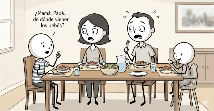
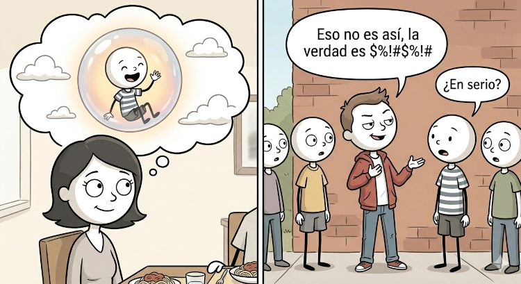
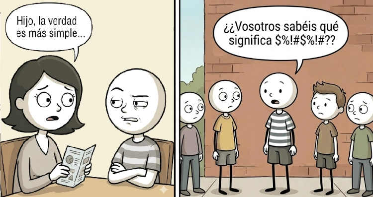
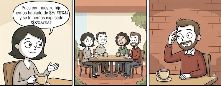
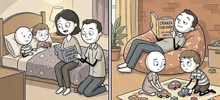
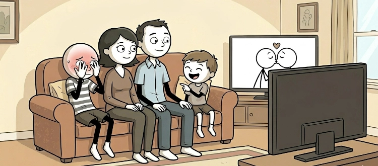
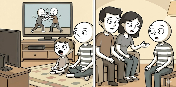
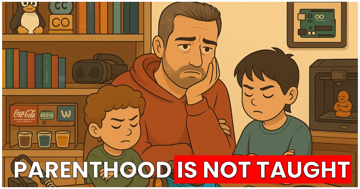

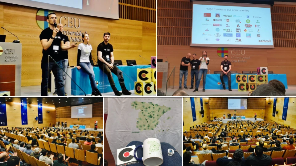
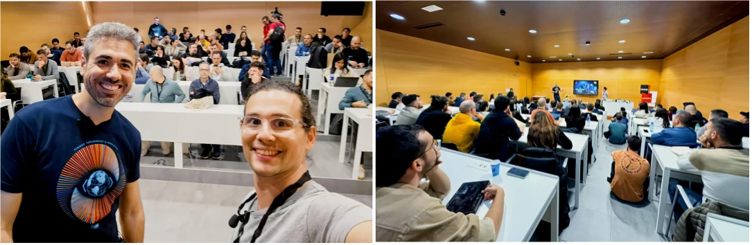
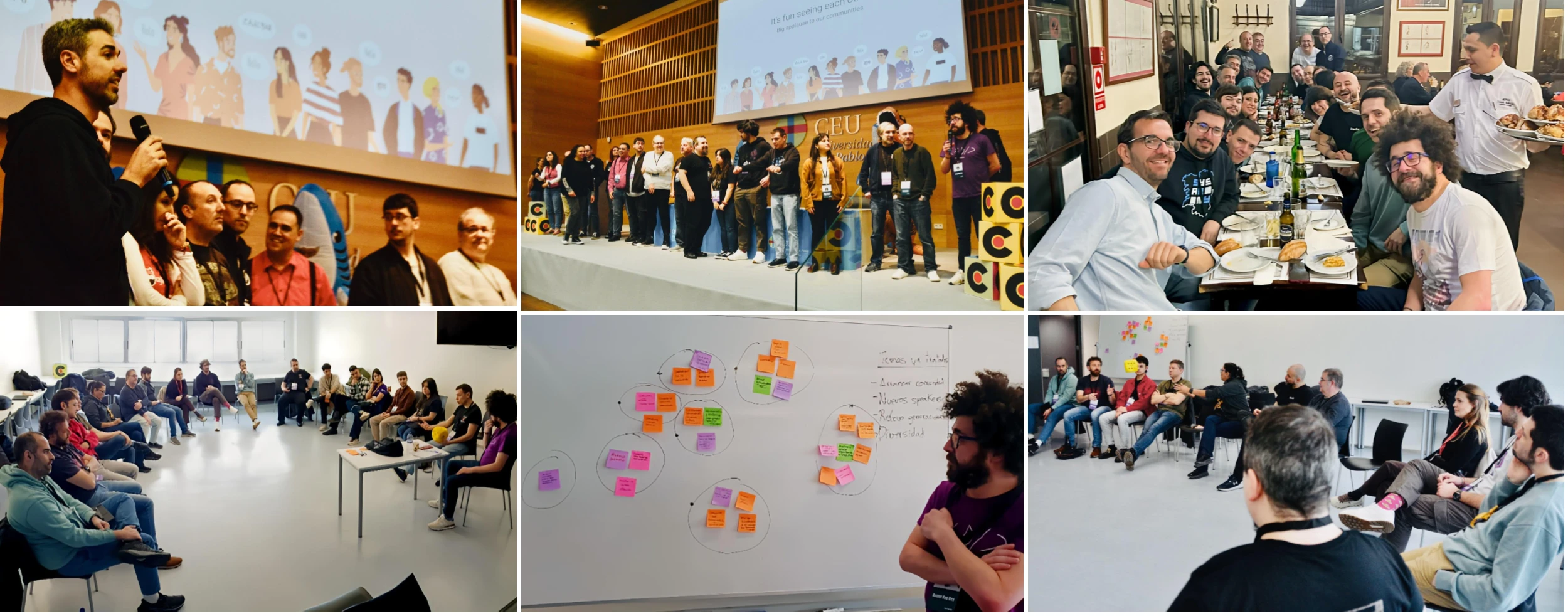

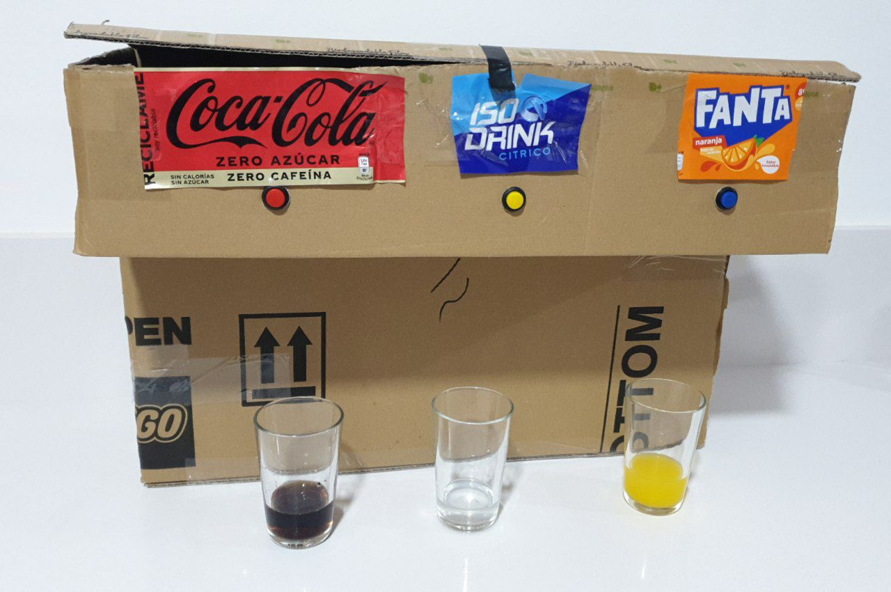
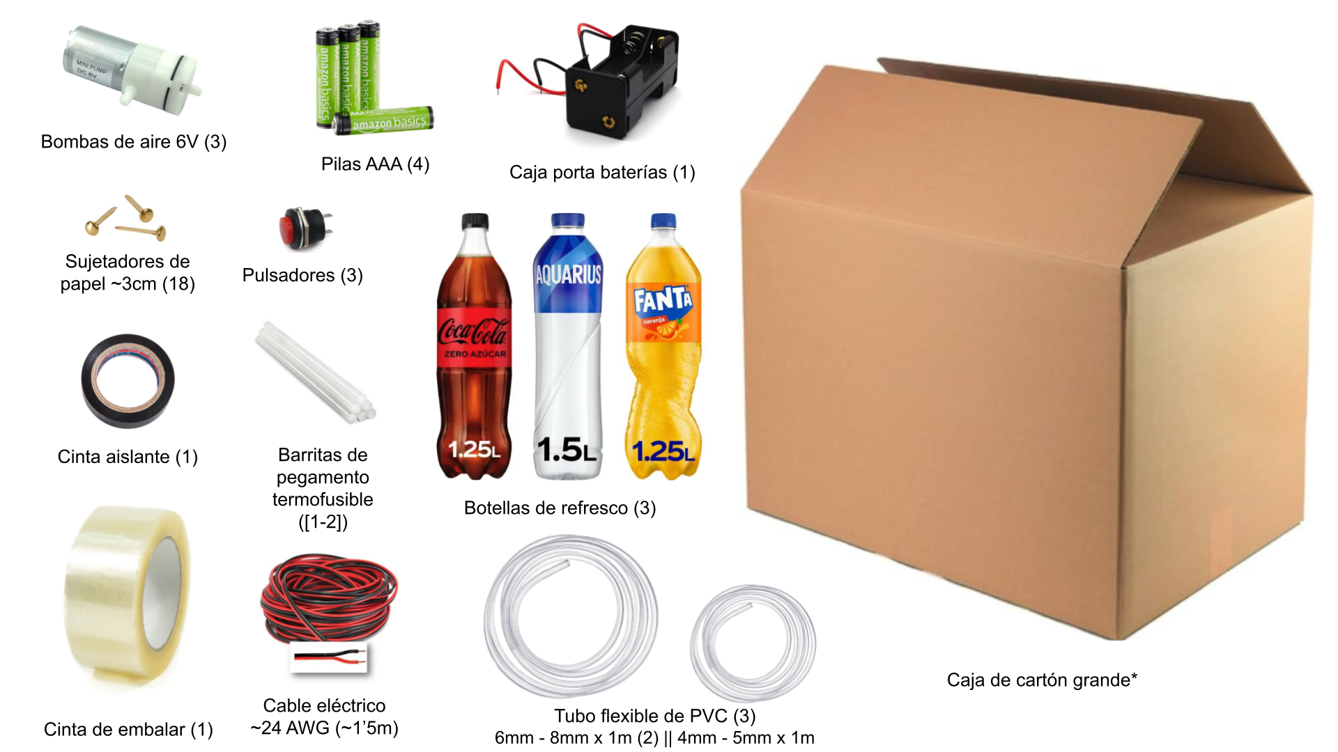
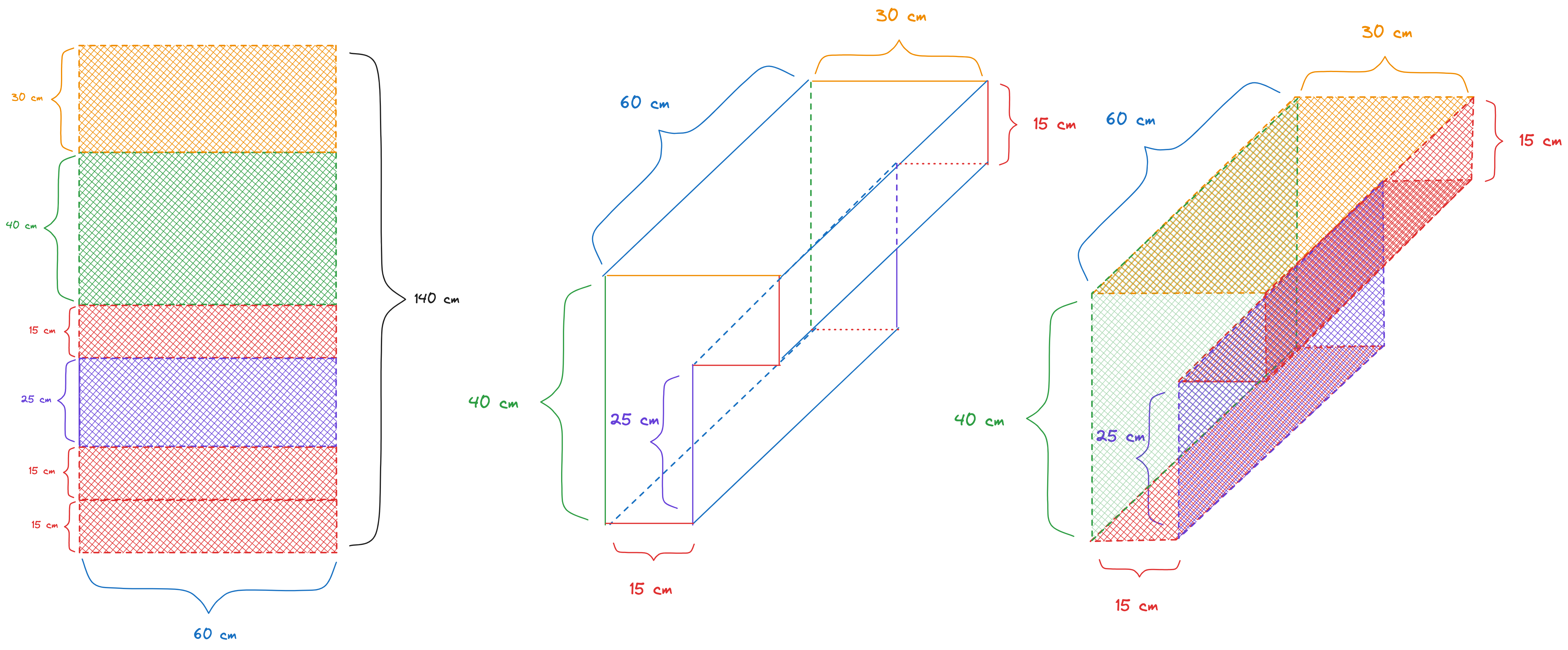

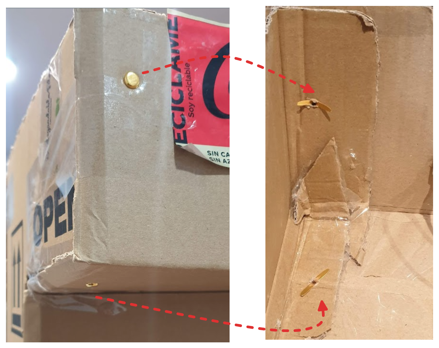

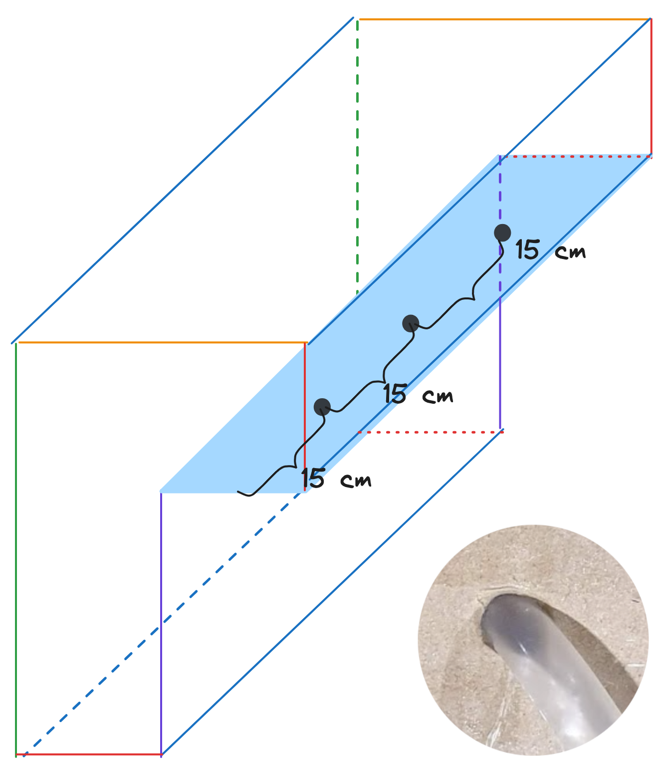
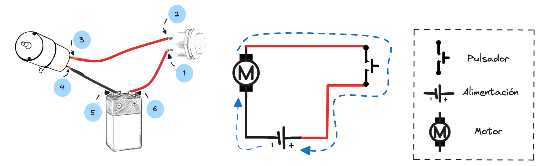
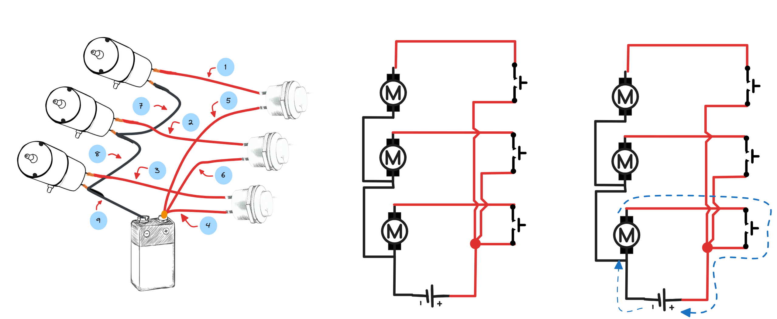
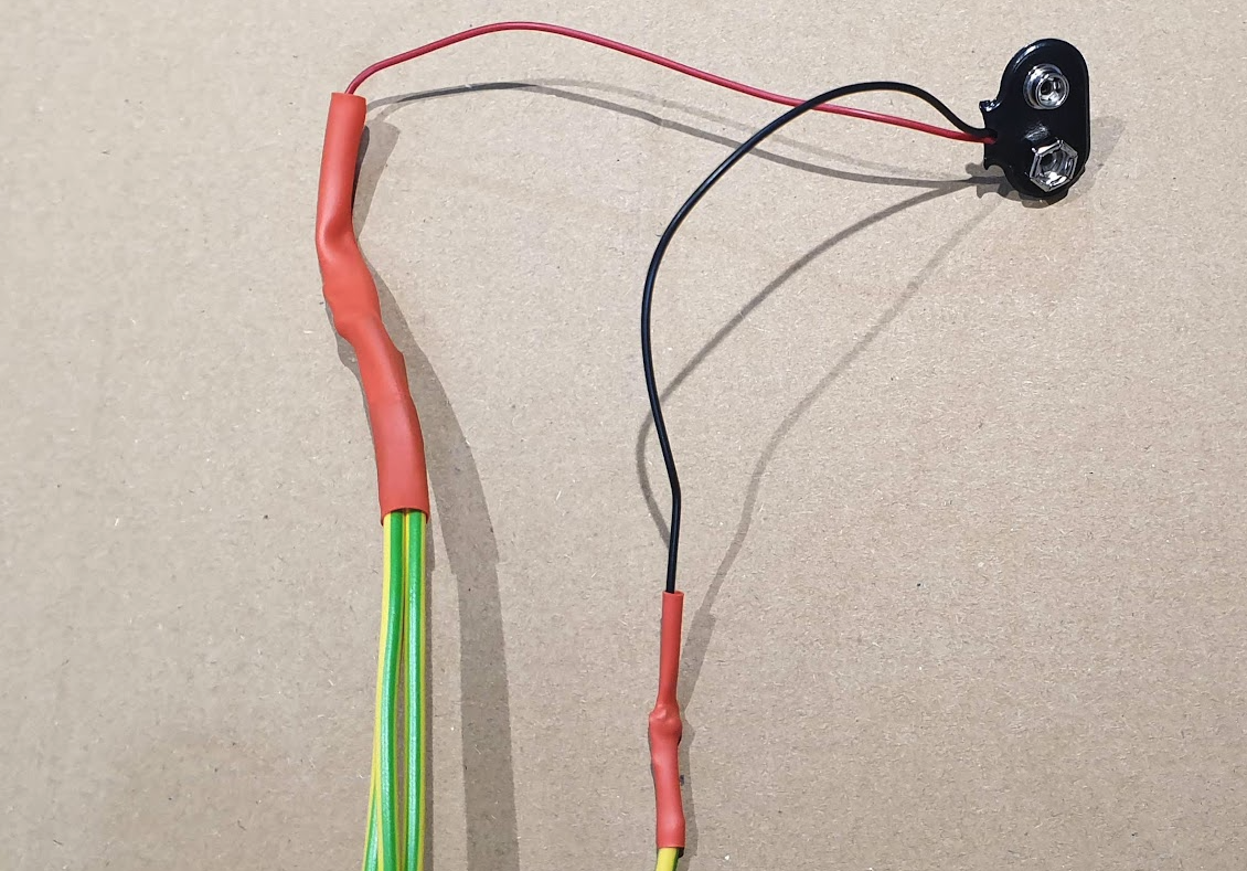
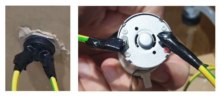
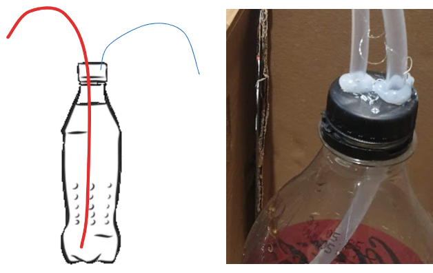
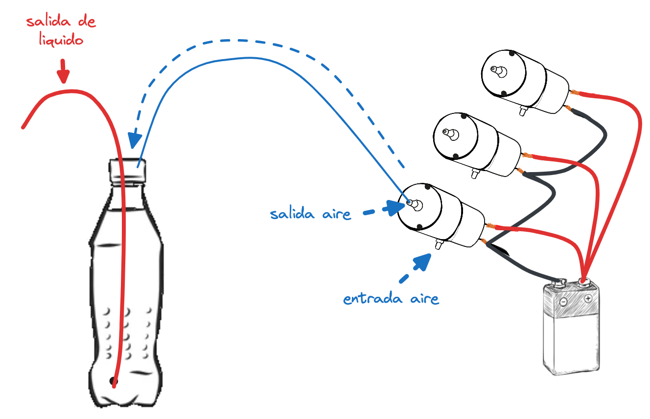
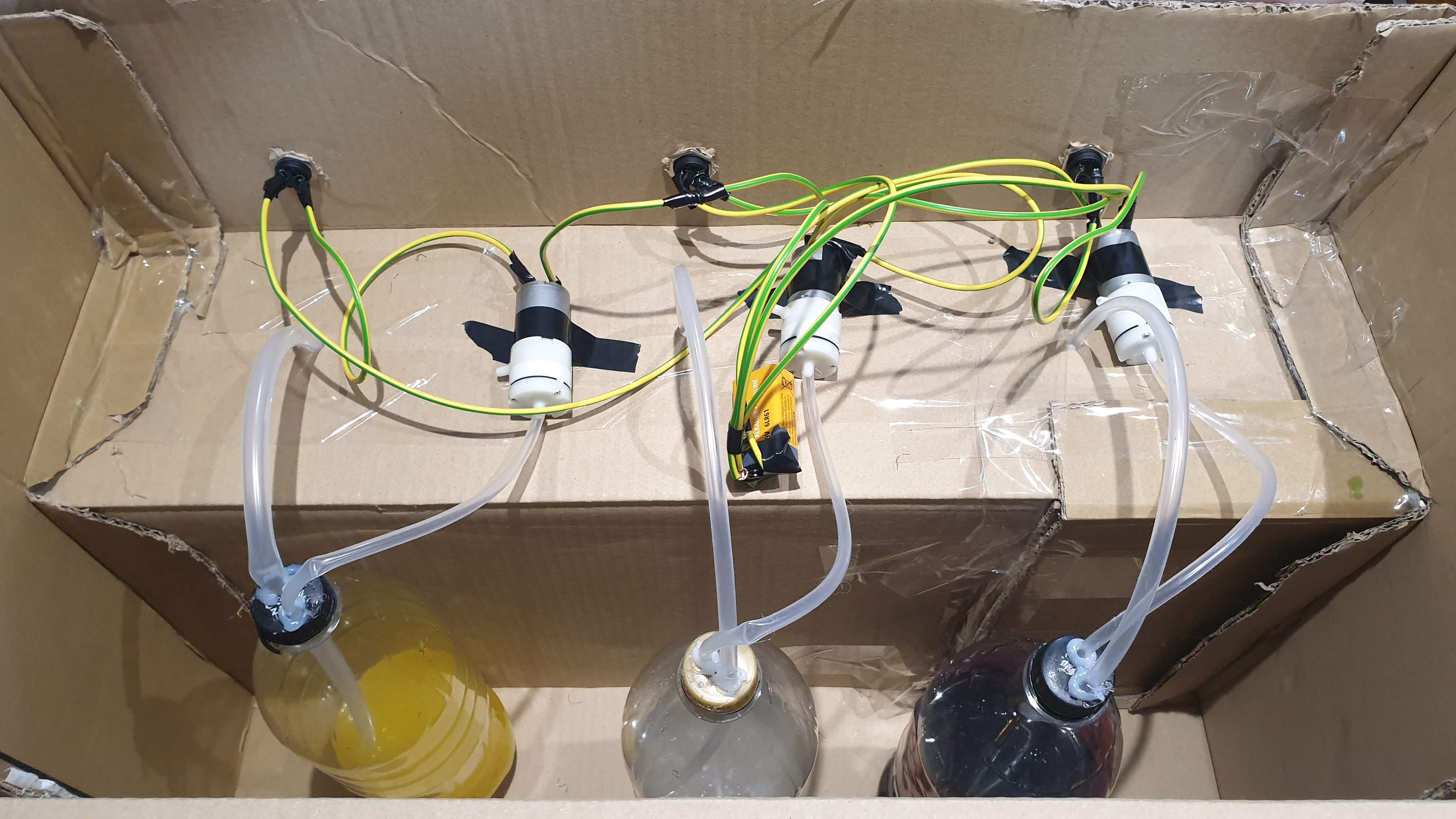
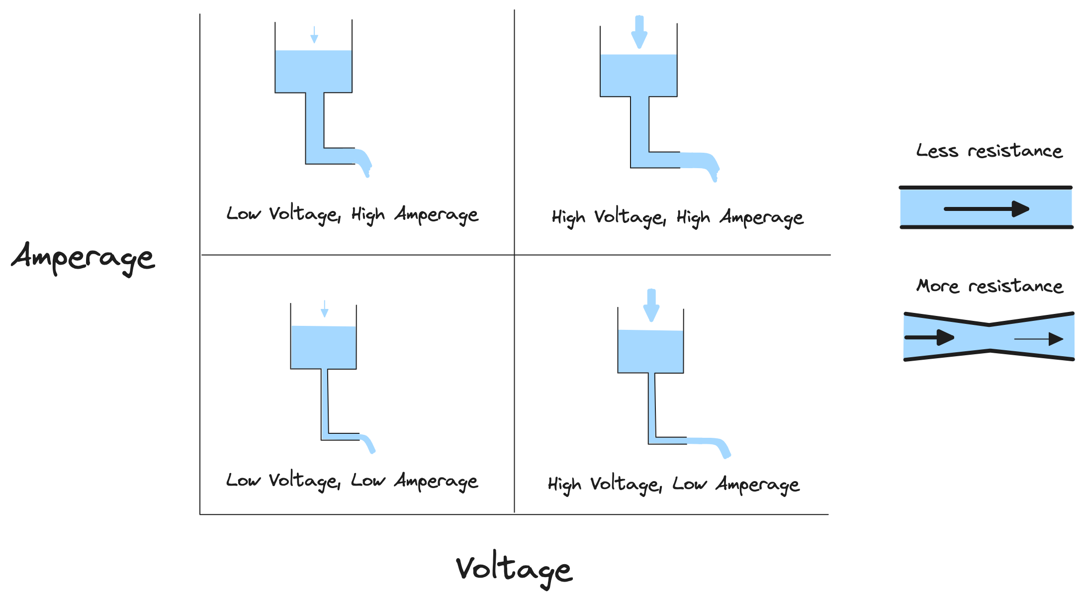
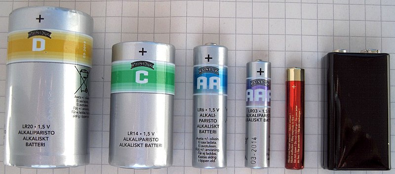

)

